


Dalham Unidentified

listed building grade II
last updated Nov 6th, 2021.
Something we've got wrong about this establishment? Something more you think we should know about it? Please email us
Dalham Unidentified
East, 52.22468,0.51895
 Closed: between 1884 and 1903?
off Lidgate Rd
grid reference TL 721 614
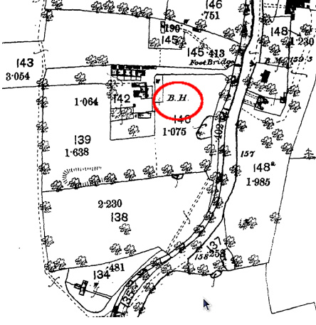
A beerhouse is shown at this location on the 1884 OS map. It seems to be gone by the 1903 sheet, so probably closed between those dates.
This may be the King's Head, though we have no evidence at present to connect the two.
Alternatively, this may be the location of the grocer and beer seller William Lofts, see the Dalham Historical Info. section for 1881 to 1888.
The building is in the Listed Buildings Register as "Robin Hill" and dates from the 17th century.

Gallery


 Affleck Arms 0.14 mile
 Chequers 1.60 miles
 Fox 2.2 miles
 Packhorse Inn 2.4 miles
 Three Horseshoes 2.9 miles
 Weeping Willow 3.1 miles
(Most pub, location & historic details collated by Nigel, Tony or Keith - original sources are credited)
